Significant Weather (SIGWX) forecasts
Significant Weather (SIGWX) forecasts
Description
Upper air forecasts provide essential wind, temperature, and weather hazard information to support safe and efficient high-altitude flight operations.
The World Area Forecast Centres (WAFCs) designated by ICAO provide global upper air forecasts used by commercial airlines and other high-altitude aviation sectors, such as business jets. These forecasts include wind and temperature data at cruising altitudes as well as Significant Weather (SIGWX) charts.
SIGWX Charts
SIGWX charts highlight en-route hazards such as:
- Jet streams (winds equal to or greater than 80 kts)
- Turbulence
- Icing
- Cumulonimbus clouds
- Volcanic ash
- Tropical cyclones
SIGWX charts may also indicate the location of a release of radioactive materials into the atmosphere that is of significance to flight operations.
SIGWX charts are issued at multiple time steps (e.g. T+6 to T+48 hours) in 3-hour intervals and are updated regularly and distributed via the SADIS system and aviation briefing platforms.
"High Level SIGWX" forecasts are valid between FL250 and FL600.
"Medium Level SIGWX" forecasts are valid between FL100 and FL450.
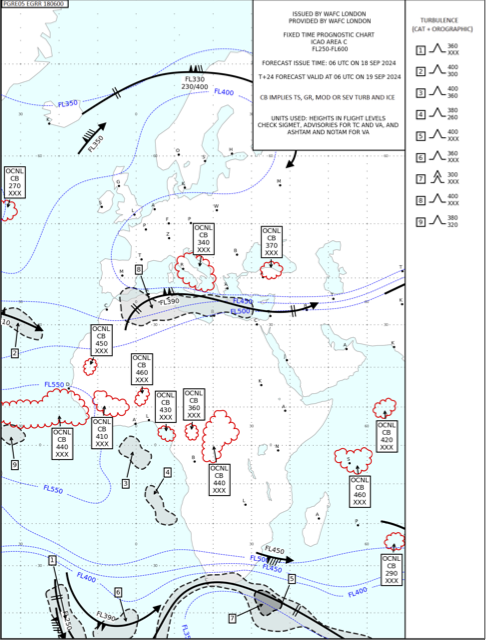
Example high-level SIGWX chart [Source: UK Met Office Guidelines for interpreting World Area Forecast Centre T+24 Significant Weather forecasts - Version 2.01, 7 Oct 24]
BUFR
As well as publishing sets of charts for fixed coverage areas in PNG format, both WAFCs produce their SIGWX forecasts in a digital format known as BUFR (Binary Universal Form for the Representation of meteorological data, developed and maintained by the World Meteorological Organisation (WMO)) which enables the end user to generate bespoke and custom visualisations relevant to the flight of flights being undertaken. This also permits overlaying of SIGWX forecast with other features as the user wishes (navigation aids or airspace reservations for example).
Further Reading
- Guidelines for interpreting World Area Forecast Centre T+24 Significant Weather forecasts - Version 2.01, 7 Oct 24.
Categories